ForestSAT2026: Special Session: Applying New Technologies to Forest Hurricane Research
The Jones Center Landscape Ecology Lab is hosting two sessions on hurricane-resilient forests at ForestSAT2026 (May 4-8, Gainesville, FL). Eight presentations showcase terrestrial lidar, UAV, and satellite remote sensing innovations for understanding forest resilience to intensifying tropical cyclones. Researchers from across the southeastern United States will present cutting-edge work on hurricane-adaptive canopy traits, wind disturbance impacts, damage assessment using deep learning, and ecological recovery.
NA-IALE: Hurricane Ecology and Restoration (International Association for Landscape Ecology)
The Jones Center Landscape Ecology Lab will showcase restoration and ecology research at the 40th Annual IALE-North America Meeting in Athens, GA. Our team will present three talks, three posters, and a hands-on workshop on lidar analysis in R, advancing our understanding of hurricane impacts on forests, remote sensing applications for restoration monitoring, and sustainable forest management in longleaf pine ecosystems.
Measuring Fire Injury with Lidar: New Research and podcast interview on Fire Ecology Chats
We joined a recent episode of Fire Ecology Chats, to discuss our lab’s new research using terrestrial lidar to measure fire-caused crown scorch in longleaf pine. By linking lidar return intensity to scorch severity, this approach offers a faster, more objective alternative to traditional ocular estimates—scaling fire effects measurements from individual trees to entire stands. The conversation explores implications for fire ecology, forest monitoring, and operational fire effects research.
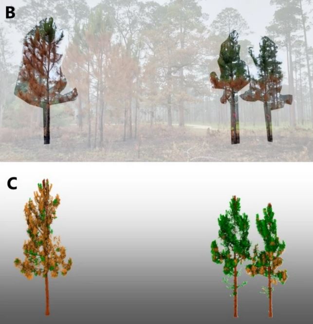
New Study: Terrestrial lidar provides accurate and objective measures of crown scorch

A new study from our lab shows that terrestrial LiDAR scanning (TLS) can measure crown scorch in longleaf pine with unprecedented speed and objectivity. TLS provides high-resolution, quantitative estimates of fire-caused crown damage—at least 20× faster than traditional ocular methods. The CrownScorchTLS R package makes these tools accessible for researchers and land managers, enabling more precise, mechanistic studies of fire impacts on forests.
Longleaf Alliance: Lab Studies in Hurricane Ecology

Join the members of the Jones Center Landscape Ecology Lab as we present our latest research at the 15th Biennial Longleaf Conference, taking place from October 7 to 11, 2024, in Miramar Beach, Florida.
Presentations from our lab will focus on hurricane ecology in longleaf pine, considerations for management hurricane risk to longleaf pine ecosystems, and two lab members will debut work on hurricane ecology using dendrochronological and remote sensing techniques